Skip to content
360° Space
Modern technologies for business development
360° Space
  • Home
  • Project Catalog
  • Calculator
  • Services
  • Areas of application
    • Real Estate
    • Developers
    • Retail
    • Architects
    • Exhibitions and museums
    • Manufacturing
    • Hotel business
    • Clubs and restaurants
    • Fitness clubs
  • Measured surveys and BIM
    • Measured plans
    • Wall elevations
    • Building BIM model
    • Laser Scanning
    • Construction progress monitoring
    • Surveying with SRO authorisation
    • Concealed works
    • Facade measured surveys
  • Blog
  • Laser Scanning
  • Acoustics
+7 985 332 65 67 Moscow+7 981 881 00 42 Saint Petersburg
360° Space360° Space
  • Home
  • Project Catalog
  • Calculator
  • Services
  • Areas of application
    • Real Estate
    • Developers
    • Retail
    • Architects
    • Exhibitions and museums
    • Manufacturing
    • Hotel business
    • Clubs and restaurants
    • Fitness clubs
  • Measured surveys and BIM
    • Measured plans
    • Wall elevations
    • Building BIM model
    • Laser Scanning
    • Construction progress monitoring
    • Surveying with SRO authorisation
    • Concealed works
    • Facade measured surveys
  • Blog
  • Laser Scanning
  • Acoustics

360° aerial photography for sites and residential developments: showcasing the location and surroundings

You are here:
  1. Home
  2. Blog
  3. Аэросъёмка 360° территорий и ЖК:…
Sep182026
BlogАэросъёмка 360° территорий и ЖК: показываем контекст и окружение

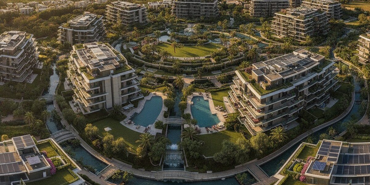
360° aerial photography has become one of the most effective tools for showcasing sites and residential developments in the context of their surroundings. Professional aerial photography produces detailed panoramas that allow potential buyers or tenants to assess a property's location, infrastructure and transport connections. In this article, we explore the features of 360° aerial photography and its benefits for builders and property developers.

What is 360° aerial photography?

360° aerial photography captures images from the air to create detailed panoramas of properties and sites. It uses specialist cameras and unmanned aerial vehicles (UAVs) equipped with high-quality lenses and sensors.

360° aerial photography produces interactive panoramas that can be viewed on a computer, smartphone or tablet. These panoramas allow users to explore a property or site from different angles and assess its location and surroundings.

Benefits of 360° aerial photography for builders and property developers

360° aerial photography offers several benefits for builders and property developers. First, it allows potential buyers or tenants to assess a property or site without visiting in person.

Second, 360° aerial photography helps build confidence in a property or site, as potential buyers or tenants can assess its location, infrastructure and transport connections for themselves.

Third, 360° aerial photography can be used to showcase properties or sites at different stages of construction or renovation, helping builders and developers attract potential buyers or tenants at an early stage.

360° Aerial Photography for Residential Developments

360° aerial photography is particularly valuable for residential developments, as it allows potential buyers or tenants to assess the location, amenities and transport links.

For residential developments, 360° aerial photography can showcase the following:

  • The location of the residential development in relation to nearby amenities (schools, nurseries, shops, transport hubs, etc.)
  • Amenities within the residential development (parking, playgrounds, sports facilities, etc.)
  • Transport links to the residential development (nearest public transport stops, distance to city centres, etc.)

How can I arrange 360° aerial photography?

You can arrange 360° aerial photography through professional companies specialising in aerial photography and interactive panorama production.

When choosing a company, consider the following factors:

  • The company's experience and expertise in aerial photography
  • The quality of the equipment and technology the company uses
  • Service pricing and project turnaround times

Conclusion

360° aerial photography is an effective way to showcase sites and residential developments in their surroundings. It allows prospective buyers or tenants to assess a property or site without visiting in person, builds confidence in what they see, and can showcase properties or sites at different stages of construction or redevelopment.

ЖК Holiday House 3D Model
Residential complex Holiday House
Ночной Петербург. Аэросъемка 3D Model
Night St. Petersburg. Aerial photography
View all projects →

If you are interested in arranging 360° aerial photography for your property or site, we recommend contacting professional companies specialising in aerial photography and interactive panorama production. For more information and to calculate the price of these services, please use the following links:


Calculate costProject CatalogMatterport
  • Facebook
  • Share on X
  • LinkedIn
  • WhatsApp
  • Email
  • Copy Link

Order a 3D tour for your property

Leave your contact — we'll respond within 30 minutes and calculate the cost


    Category: BlogBy 360° Space18.09.2026

    Author: 360° Space

    Post navigation

    PreviousPrevious post:360° video for properties and events: technology and applicationsNextNext post:VR tours for showrooms: immersive sales experiences without an in-person visit

    Related Posts

    AI-иллюстрация к статье: Сезонные объекты в Pro3D: календарь публикации, архив и бюджет размещения
    Сезонные объекты в Pro3D: календарь публикации, архив и бюджет размещения
    01.11.2026
    AI-иллюстрация к статье: План этажа Pro3D и чертёж DWG: разные задачи, состав файлов и приёмка
    План этажа Pro3D и чертёж DWG: разные задачи, состав файлов и приёмка
    31.10.2026
    AI-иллюстрация к статье: Доступ к туру Pro3D: как выбрать открытый, ссылочный, парольный или закрытый режим
    Доступ к туру Pro3D: как выбрать открытый, ссылочный, парольный или закрытый режим
    30.10.2026
    AI-иллюстрация к статье: Совместный просмотр Pro3D: сценарий удалённой экскурсии от приглашения до обратной связи
    Совместный просмотр Pro3D: сценарий удалённой экскурсии от приглашения до обратной связи
    28.10.2026
    AI-иллюстрация к статье: Как встроить тур Pro3D на сайт и проверить просмотр на телефоне
    How to embed a Pro3D tour on your website and test it on a phone
    23.10.2026
    AI-иллюстрация к статье: Информационные метки в туре Pro3D: как помочь зрителю и не перегрузить пространство
    Information tags in a Pro3D tour: how to guide viewers without cluttering the space
    22.10.2026
    Go to Top
    360 Space

    © 360°Space 2017–2026

    Sole Proprietor Gonchar Maksim Alexandrovich

    TIN 501818387709

    OGRN 319508100030536

    Privacy Policy

    Consent to the processing of personal data

    Moscow
    +7 (985) 332 65 67
    Saint Petersburg
    +7 (981) 881 00 42
    Email
    info@360space.ru
    Social media
    Facebook · Rutube · VK
    • Development
      • 3D mapping
      • 3D modeling
      • AR development
      • METAVERSE
      • VR development
      • Mobile app
      • Website Development
      • Development of objective monitoring systems (OMS)
    • Visualization
      • 3D tours
      • 3D tours for Google Maps
      • 3D tours for Yandex Maps
      • Laser Scanning
      • Aerial photography
      • 360 Video
      • Video production and editing
      • Photography

    Quick access

    • Cost calculator
    • Blog
    • 360° Space Acoustic →
    .

    We use cookies and analytics services to make the site work better. By continuing to use the site, you agree to cookie policy And privacy policy.

    English
    Russian
    360 Space Acoustic
    RUEN